Updated February 26, 2026 09:42AM
10 Best National Parks for Scenic Drives from National Geographic
Take a peek inside National Geographic’s newest book, The 10 Best of Everything National Parks, 2nd Edition, and discover the most incredible scenic drives across America.
Yosemite National Park (Photo: Getty)
Take a peek inside The 10 Best of Everything National Parks, 2nd Edition: 800 Top Picks From Parks Coast to Coast, an updated book from National Geographic. Wondering what might be the best national park scenic drives? Filled with top 10 lists from more than 400 national park sites, your bucket list will grow exponentially flipping through these pages. Part inspiration featuring beautiful photography, part practical planning advice with tips from rangers, hotel recommendations, restaurants and more, this volume is the perfect start to any national park vacation. Available December 3, 2024 at books.disney.com
The following is an excerpt from The 10 Best of Everything National Parks, 2nd Edition.

10 Best Parks for Scenic Drives
There is no substitute for getting out and seeing a national park up close, whether on foot, on horseback, on a bicycle, or in a canoe. But it’s also entertaining, and certainly less exhausting, to be presented with one superlative view after another in a relatively short time, as is the case with our most spectacular scenic drives.
1. Glacier National Park, Montana
“One of the world’s most spectacular highways” is Glacier National Park’s own description of Going-to-the-Sun Road, and no one who has traveled this 50-mile mountain route between the park’s east and west entrances would argue. Stretching over the Continental Divide in northwestern Montana, the road’s glacier-carved Rocky Mountain locale provides countless eye-filling vistas, scenic overlooks, waterfalls, and access to short trails. Dedicated in 1933, the drive was named for nearby Going-to-the-Sun Mountain. How the mountain got its name is uncertain—some say from an ancient Native American legend, while others say the “legend” was created by an explorer in the 1880s. The route, open seasonally, reaches its literal high point at 6,646-foot Logan Pass, where, in addition to knife-edged ridges, sheer cliffs, and sharp-pointed peaks, there may be mountain goats and bighorn sheep within sight. East of Logan Pass there’s a view to the south of Jackson Glacier, one of the few glaciers in the park visible from a road. Lesser snowfall on the eastern side means Going-to-the-Sun Road stays open longer and higher in fall here than it does on the western slope. Plan ahead: Based on the season and hours you plan to embark, reservations for the road are most likely required.
ADVERTISEMENT
2. Shenandoah National Park, North Carolina & Virginia
The Blue Ridge Parkway in western North Carolina and Skyline Drive in western Virginia are administered by two different National Park Service units. It makes sense to treat them as one route, though: The northern terminus of the 469-mile Blue Ridge Parkway links with the southern end of 105-mile Skyline Drive (part of Shenandoah National Park) at Rockfish Gap, Virginia, creating a 574-mile drive that takes in some of the most beautiful scenery of the central Appalachian Mountains. In addition to dozens of overlooks providing views of forested ridges and valleys, attractions along the combined drives (many open only seasonally) include visitor centers, lodges, campgrounds, restaurants, the Folk Art Center, the Museum of North Carolina Minerals, the historic Skyland resort, and hiking trails leading to mountain summits, waterfalls, and other natural features. Both drives are well marked with mileposts, making it easy for travelers to keep up with their location and find special sites. With limited entrances and exits, no billboards, and speed limits of 45 miles an hour on the Blue Ridge Parkway and 35 on Skyline Drive, this combined route offers an experience as relaxing as it is beautiful.
3. Rocky Mountain National Park, Colorado
Just before Trail Ridge Road was completed in 1932, the director of the Park Service described its appeal: “You will have the whole sweep of the Rockies before you in all directions.” Winding for 48 miles to cross the Continental Divide between Estes Park and Grand Lake, Colorado, this scenic route 60 miles northwest of Denver rises to a high point of 12,183 feet, making it the highest continuous road in the United States. It takes drivers from ponderosa pine forest through the zone of spruce and fir to the open tundra, with magnificent views of valleys, lakes, rivers, and mountains, including 14,259-foot Longs Peak, the park’s highest summit. Overlooks such as Many Parks Curve, Rainbow Curve, and Rock Cut provide panoramas that truly give you the impression of being on top of the world. People with difficulty breathing should beware the thin air. At Fall River Pass, a visitor center has exhibits interpreting the harsh environment above tree line, where only the hardiest plants and animals can survive. Heavy snow may close Trail Ridge from mid-October until late May. Rocky Mountain is one of the country’s busiest national parks, and timed entry permits are currently required.
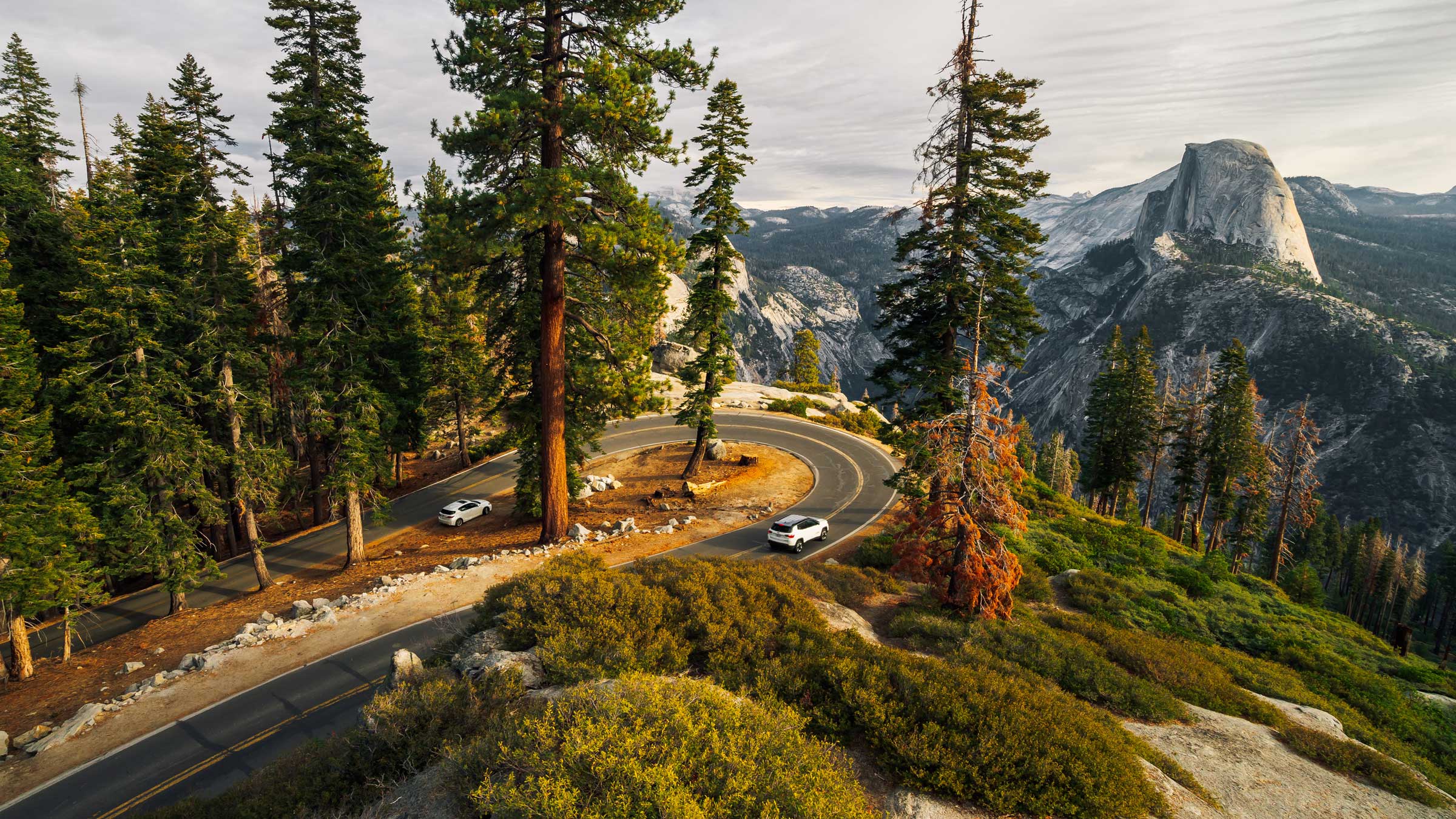
4. Yosemite National Park, California
Three separate roads in Yosemite are close enough together that all can be traversed in five hours or so, if one was so inclined. Yosemite Valley, 195 miles southeast of San Francisco, boasts far more than its share of natural icons visible from the road: Highlights include 620-foot Bridalveil Fall, the massive granite monolith of El Capitan, 1,000-foot Horsetail Falls, Yosemite Falls (three falls totaling 2,425 feet), and Half Dome. The famed overlook Tunnel View, on the road out of Yosemite Valley toward Wawona, offers what is perhaps the park’s single most famous vista. To the south, Glacier Point Road climbs up to Glacier Point, 3,200 feet above Yosemite Valley, another awesome panorama of the valley, peaks, and waterfalls. Bisecting the park to the north of the valley, Tioga Road runs west–east to cross the Sierra Nevada via the 9,945-foot Tioga Pass. Originally a wagon road built in 1883, Tioga Road ascends into an alpine world of snowy peaks, crystal lakes, and meadows bright with wildflowers.
ADVERTISEMENT
5. Crater Lake National Park, Oregon
Rangers at southwestern Oregon’s Crater Lake are occasionally asked what they put in the water to make it so blue. The truth is that the striking deep azure color is completely natural, a result of the purity of the water and its stupendous depth. At 1,943 feet deep, Crater Lake is the deepest lake in the United States and one of the 10 deepest in the world. The lake is actually a caldera, a crater formed after a massive volcanic explosion 7,700 years ago. The park’s Rim Drive (closed November through May, depending on snowfall) winds for 33 miles around Crater Lake, with more than 30 scenic overlooks offering an ever changing perspective. Must-see stops include Watchman Overlook, with a great view of Wizard Island, a cinder cone rising in the lake; Phantom Ship Overlook, where a small island resembling a ship is visible; the spur road to the Pinnacles, a collection of 100-foot-tall spires; and Vidae Falls, where a creek drops 100 feet over a series of ledges.
6. Organ Pipe Cactus National Monument, Arizona
Located 120 miles southwest of Tucson, Organ Pipe Cactus rewards travelers with a beautifully rugged volcanic landscape and an environment so biodiverse that the area was designated an international biosphere reserve in 1976. The 21-mile Ajo Mountain Drive loops east of Ariz. 85, circling the Diablo Mountains to skirt the Ajo Range, providing a good overview of the park. The gravel and asphalt road is suitable for all vehicles and takes about one to two hours to drive. Much of the breathtaking scenery is composed of rhyolite, rock formed by lava cooling on the earth’s surface. In many places, cliffs display bands of dark rhyolite paralleling lighter bands of tuff, volcanic ash compressed and “welded” into rock. Among the plants visible in the desert are organ pipe cactus, elephant tree, and the saguaro cactus, symbol of the Sonoran Desert. Nine miles into the loop, a natural rock arch 90 feet wide appears on a cliff above the road. In higher elevations the desert gives way to a landscape of oaks, junipers, and jojoba, a shrub favored by bighorn sheep, which might be spotted here.
7. Theodore Roosevelt National Park, North Dakota
It’s worth the time to stop and set the scene before embarking on the South Unit’s scenic drive. At the South Unit Visitor Center in Medora, a brief film and a selfguided tour of the 26th president’s Maltese Cross Cabin give insight into the rigorous North Dakota landscape that became the backdrop of Roosevelt’s formative 20s. “I never would have been President if it had not been for my experience in North Dakota,” he once wrote. With this insight as your guide, the views of beautiful badlands, prairie dog towns, and abundant wildlife become all the more evocative. Although traffic is nearly always light in this park, plan at least two hours to take in the drive, which is speckled with overlooks, interpretive signage, and trailheads leading to hiking and biking paths. Erosion is quite common in this region, so check with rangers at the visitor center regarding vehicle closures.
ADVERTISEMENT
8. Capitol Reef National Park, Utah
Located in southern Utah, Capitol Reef encompasses striking rock formations typical of the Colorado Plateau, intriguing historic sites, and a wonderland of canyons, buttes, washes, and back roads to explore. The Cathedral Valley Loop Drive covers 58 miles of rough, unpaved road that can be impassable at times. Check with the park visitor center on Utah 24 before setting out. The route, which can take upwards of eight hours, begins with a ford of the Fremont River that is passable most of the time, except during high water after storms and for more extended periods during spring runoff. The road continues to pass alongside multicolored mesas, spires, and other rock formations with names such as Walls of Jericho and the Temple of the Moon. Quite visible in many places are black boulders that look different from the rest of the landscape. Remnants of lava flows that capped nearby mountains about 20 million years ago, they were eroded and later moved to lower locations by various processes including glacial melting. After heading northwest, the loop turns back southeast on Caineville Wash Road. There are several panoramic vistas along the route, which returns to Utah 24 at the community of Caineville.
9. Colorado National Monument, Colorado
At Colorado National Monument, taking the scenic route is the most popular pastime. The 23-mile Rim Rock Drive winds up wild switchbacks to the tip-tops of mesas and along steep canyon walls before descending into the valley, featuring overlooks, trails, and interpretive panels along the way. Consider starting in Fruita, Colorado: The drive entrance is just four miles from the visitor center, and you’ll want to pick up geology pamphlets to inform your route. If heights give you pause, Rim Rock’s tight drop-off sections may prove difficult to tolerate. But those that take the challenge can take in red-rock canyons, bighorn sheep, soaring eagles, and layers of rock dating back 1.7 billion years. Just remember to share the road: Bicyclists find the scenery equally stunning, and the narrow navigation requires alert drivers.
10. Acadia National Park, Maine
Maine is justly famous for its ruggedly beautiful rocky shoreline, where waves continuously crash into reddish granite ledges while the boats of lobstermen cruise by. An especially striking section of this coast is a highlight of Acadia National Park’s 27-mile Park Loop Road, which winds around the eastern section of Mount Desert Island, south of the town of Bar Harbor. Open from about April 15 through November, the road provides access not only to the coast but also to lush forests, lakes, the park’s famed carriage roads— broad paths suitable for hiking or biking—and an extension leading to the top of 1,530-foot Cadillac Mountain, the tallest summit on the East Coast. Coastal sites reached by the scenic drive include Sand Beach, where those who can tolerate 55-degree water swim; Thunder Hole, where heavy surf compresses air in a hole in the rocks, causing a low booming sound; and Otter Cliffs, one of the most picturesque sections of rocky coast.
ADVERTISEMENT
Tip: Park visitor centers hold a wealth of information, including free scenic road guidebooks highlighting suggested stops, interesting history, and traveler tips. Check park websites, too, as some have engaging audio tours you can download and stream as you drive.
Learn more and buy your copy at books.disney.com.